

GARMIN |
Ref: 010-02347-11
Garmin GPS Navigator Montana 700i
Details
https://www.greenlandmx.co.uk/en/garmin-gps-navigator-montana-700i/010-02347-11.html
GARMIN |
Ref: 010-02347-11
Garmin GPS Navigator Montana 700i
Personalized
Customer Service
Pay less
Get more
Club GMX
Exclusive Discounts
📢WEEKLY OFFER
(*) Promotion valid until 11/05/2024 at 23h59 CEST. Not combinable with other offers, outlet or promo codes. Motorcycle, Bikes and OEM parts are excluded from the offer. Some brands may be excluded from the promotion.
MSRP
727.99£
|
You save
99.01£
GMX Price
-14%
628
.
98
£
VAT Included
With free shipping
Did you find it cheaper?


Description
Technical details
Ratings
Garmin GPS Navigator Montana 700i
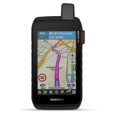
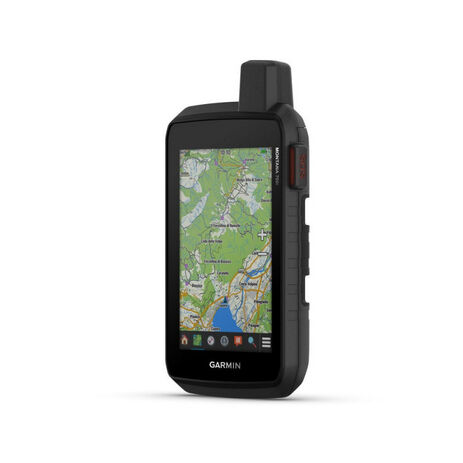
GO INTO THE WILD WITH A SATELLITE CONNECTION
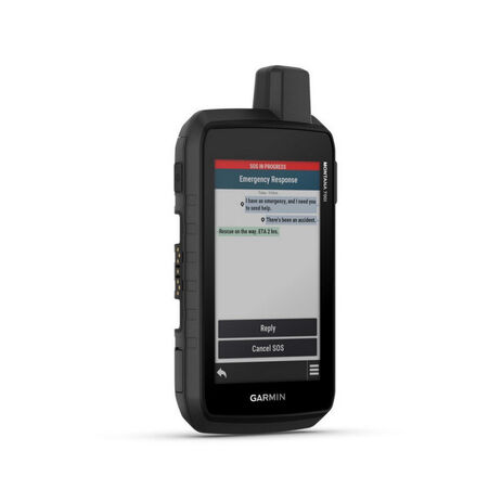
To keep adventurers in touch and on track, the Montana 700i handheld combines the flexibility of on- or off-road navigation with global messaging and interactive SOS via inReach satellite technology1.
- Big news. A full QWERTY keyboard lets you easily type messages.
- Wander wider and still stay in touch — with inReach for messaging and 24/7 SOS.
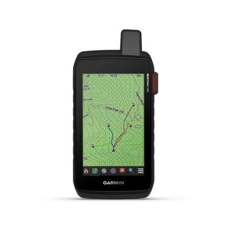
- Routable TopoActive Europe maps. Now you’re free to take it off-road or on.
- Meets MIL-STD 810 for thermal, shock, water and vibration.
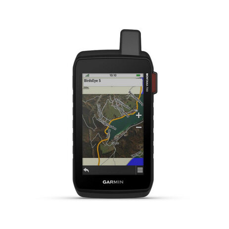
- Get a clear perspective of BirdsEye Satellite Imagery right to your device.
- Power your adventures with 18+ hours of lithium-ion battery life in GPS mode.
- TWO-WAY MESSAGING: Exchange text messages with loved ones, post to social media, or communicate via inReach device to inReach device in the field (active satellite subscription required).
- INTERACTIVE SOS: In case of emergency, trigger an interactive SOS message to GEOS, the Garmin-powered International Emergency Response Coordination Centre (IERCC) with professional 24/7 global monitoring and response center (active satellite subscription required).
- GLOBAL CONNECTIVITY: Instead of relying on mobile phone coverage, now your messages, SOS and tracking are transferred via the 100% global Iridium® satellite network (active satellite subscription required).
- INREACH WEATHER: Available inReach weather forecast service provides detailed updates directly to your Montana handheld or paired devices, so you’ll know what to expect en route.
- RUGGED BY DESIGN: This durable, water-resistant handheld is tested to U.S. military standards and features a glove-friendly 5” touchscreen that’s 50% larger than previous Montana models.
- CITY NAVIGATOR MAPS: Seamlessly transition from trails to road navigation with preloaded City Navigator street mapping, which guides your drive with easy-to-follow turn-by-turn directions.
- TOPOACTIVE EUROPE MAPS: To navigate your adventures, use preloaded TopoActive Europe maps. View elevations, coastlines, rivers, landmarks, and more.
- SATELLITE VIEWS: Use direct-to-device downloads of Birdseye Satellite Imagery (no annual subscription required) to see photo-realistic views and create waypoints based on landmarks.
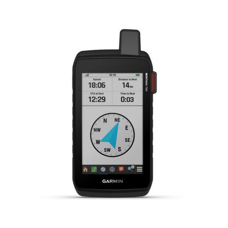
- ABC SENSORS: Navigate your next trail with ABC sensors, including an altimeter for elevation data, a barometer to monitor the weather and 3-axis electronic compass.
- ACTIVE WEATHER: Use cellular connectivity1 to access up-to-date Active Weather forecasts through the Garmin Connect app.
- DOG TRACKING: This Montana syncs with compatible Astro® or
- WIKILOC TRAILS: This preloaded app lets you easily download hiking, cycling and other Wikiloc trails shared by outdoor enthusiasts like you. Get a free 60-day Wikiloc Premium trial to try this and other exclusive features. Learn more.
General
- Dimension 9.19 x 18.30 x 3.27 cm
- Touchscreen
- Display Size 6.48 x 10.80 cm; 5" diag (12.70 cm)
- Display Resolution 480 x 800 pixels
- Display Type WVGA transflective, dual orientation
- Weight 410 g with included lithium-ion battery pack
- Battery type rechargeable lithium-ion (included)
- Battery life GPS Mode: up to 18 hours
- Expedition Mode: up to 330 hours
- GPS Mode, 10 min Tracking: up to 18 hours
- Expedition Mode, 30 min Tracking: up to 300 hours
- Water rating IPX7
- MIL-STD-810 yes (thermal, shock, water, vibe)
- Interface High speed micro USB and NMEA 0183 compatible
- Memory/history 16 GB (user space varies based on included mapping)
Maps & memory
- Preloaded maps Yes (TopoActive Europe)
- Ability to add maps
- Basemap
- Automatic routing (turn by turn routing on roads) for outdoor activities
- Automatic routing (turn by turn routing on roads) for motorized vehicles
- Map segments 15000
- BirdsEye Yes (direct to device)
- Includes detailed hydrographic features (coastlines, lake/river shorelines, wetlands and perennial and seasonal streams)
- Includes searchable points of interests (parks, campgrounds, scenic lookouts and picnic sites)
- Displays national, state and local parks, forests, and wilderness areas
- Storage and Power Capacity Yes (32 GB max microSD™ card)
- Waypoints/favourites/locations 10000
- Tracks 250
- Navigation Track Log 20000 points, 250 saved gpx tracks, 300 saved fit activities
- Navigation Routes 250, 250 points per route; 50 points auto routing
- Rinex logging
- High-sensitivity receiver
- GPS
- Galileo
- Barometric altimeter
- Compass Yes (tilt-compensated 3-axis)
- GPS compass (while moving)
- Connect IQ™ (downloadable watch faces, data fields, widgets and apps)
- Smart notifications on handheld
- Weather
- VIRB® camera remote
- Compatible with Garmin Connect™ Mobile
- Active Weather
- LiveTrack
- Point-to-point navigation
- Area calculation
- Hunt/fish calendar
- Sun and moon information
- XERO™ Locations
- Geocaching-friendly yes (Geocache Live)
- Custom maps compatible yes (500 custom map tiles)
- Picture viewer
- LED beacon flashlight
- Interactive SOS
- Send and receive text messages to SMS and email
- Send and receive text messages to other inReach device
- Exchange locations with other inReach device
- MapShare compatible with tracking
- Virtual keyboard for custom messaging
- Send waypoints to MapShare during trip
- Send route selection to MapShare during trip
- inReach remote compatible
- Compatible with Garmin Explore™ app
- Garmin Explore website compatible
- Dog tracking Yes (when paired to compatible dog track system)
- Connections Wireless Connectivity Yes (Wi-Fi®, Bluetooth®, ANT+®)
Sensors
Daily smart features
Safety and tracking features
Outdoor recreation
inReach® features
Outdoor applications
Connections
| Brand | Garmin |
-
